Timeline of the 2007–08 Australian region cyclone season
The 2007–08 Australian region cyclone season was only the second season to have a tropical cyclone form in July. This timeline documents all the storm formations, strengthening, weakening, landfalls, extratropical transitions, as well as dissipation. The season officially began on 1 November 2007, and lasted until 30 April 2008. However a tropical cyclone moving in to the region from the South-West Indian Ocean cyclone season on 29 July, meant that the season started 29 days after the Southern Hemisphere Tropical Cyclone Year started on 1 July 2007. The timeline includes information which was not operationally released, meaning that information from post-storm reviews by the Australian Bureau of Meteorology, such as information about a Cyclone that was not upgraded operationally, has been included.
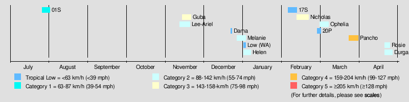
The graphical bar above gives a brief overview of storm activity during the season, and for convenience, the storm's maximum intensity on the Australian Tropical Cyclone Intensity Scale is included as a color bar.
Contents |
Timeline of storms
July
- 1 July
- 0000 UTC – The 2007–08 Tropical Cyclone year begins.
- 29 July
- 1800 UTC – Tropical Cyclone 01, moves in to the east of 90E and in to Tropical Cyclone Warning Center in Perth's area of responsibility, from RSMC La Reunion's area of responsibility.[1]
- 2100 UTC – The Joint Typhoon Warning Center designates Tropical Cyclone 01 as Tropical Cyclone 01S.[2]
- 30 July
- 0400 UTC – The Tropical Cyclone Warning Center in Perth operationally issues its first warning on Tropical Cyclone 01S, designating it as a Tropical Low.[1][3]
- 0900 UTC – The Joint Typhoon Warning Center issues its final advisory on Tropical Cyclone 01S as it begins to dissipate 310 km west of the Cocos Islands.[3]
- 1200 UTC – The Tropical Cyclone Warning Center in Perth reports in their Tropical cyclone report that Tropical Cyclone 01S weakened in to a tropical low.[1]
- 31 July
- 0600 UTC – The Tropical Cyclone Warning Center in Perth operationally issues its last warning on Tropical Low 01S, as it moves back in to RSMC La Reunion's area of responsibility.[1][3]
August
- There was no tropical cyclone activity in the Australian region during August.[4]
September
- There was no tropical cyclone activity in the Australian region during September.[5]
October
- There was no tropical cyclone activity in the Australian region during October.[6]
November
- 13 November
- 0000 UTC – The Tropical Cyclone Warning Center in Brisbane reports that a Tropical Low has formed, near south-eastern New Guinea.[7]
- 0600 UTC – The Tropical Cyclone Warning Center in Perth reports that a Tropical Low has formed, to the southwest of Sumatra.[8]
- 1500 UTC – The Joint Typhoon Warning Center designates the Tropical low that was previously located to the near south-eastern New Guinea as Tropical Cyclone 02P.[9]
- 14 November
- 0300 UTC – The Tropical Cyclone Warning Center in Brisbane reports that the Tropical Cyclone Warning Center in Port Moresby has named Tropical Cyclone 02S as Tropical Cyclone Guba.[10]
- 1200 UTC – TCWC Perth upgrades the Tropical Low that was previously located to the southwest of Sumatra to Tropical Cyclone Lee.[8]
- 2100 UTC – The Joint Typhoon Warning Center designates Tropical Cyclone Lee as Tropical Cyclone 03S.[11]
- 15 November
- 0000 UTC – Tropical Cyclone Lee intensifies in to a category 2 tropical cyclone.[12]
- 0600 UTC – TCWC Perth issues its last advisory on Tropical Cyclone Lee, as it moves west of 90°E in to RSMC La Reunion's area of responsibility, and is renamed Severe Tropical Storm Ariel.[13][14]
- 16 November
- 0000 UTC – Tropical Cyclone Guba intensifies in to a category 2 tropical cyclone.[15]
- 1200 UTC – Tropical Cyclone Guba intensifies in to a category 3 severe tropical cyclone.[16]
- 17 November
- 1200 UTC – Severe Tropical Cyclone Guba weakens in to a category 2 tropical cyclone.[17]
- 18 November
- 0000 UTC – Tropical Cyclone Guba weakens in to a category 1 tropical cyclone.[18]
- 19 November
- 2100 UTC – The Tropical Cyclone Warning Center in Brisbane issues its last warning on Tropical cyclone Guba as it weakens in to a tropical low.[19]
December
- 26 December
- 1800 UTC – A developing Tropical Low forms to the south of Sumba island.[20]
- 27 December
- 0600 UTC – The Tropical Cyclone Warning Center in Perth issues its first warning for the developing Tropical Low previously located to the south of Sumba island.[21]
- 28 December
- 0000 UTC – The Tropical Cyclone Warning Center in Perth upgrades the developing Tropical Low previously located to the south of Sumba island to Tropical Cyclone Melanie.[20]
- 0900 UTC – The Joint Typhoon Warning Center designates Tropical Cyclone Melanie as Tropical Cyclone 08S.[22]
- 1800 UTC – Tropical Cyclone Melanie intensifies in to a category 2 cyclone.[20]
- 31 December
- 0000 UTC – The Tropical Cyclone Warning Center in Perth reports that a Tropical Low has formed to the northwest of the Cocos Islands.[23]
- 0600 UTC – Tropical Cyclone Melanie weakens in to a category 1 cyclone.[20]
January
- 1 January
- 1800 UTC – Tropical Cyclone Melanie weakens in to a Tropical Low.[20]
- 2 January
- 0600 UTC – The Tropical Cyclone Warning Center in Perth issues its final warning on Tropical Low Ex Melanie as it Melanie had dissipated.[20]
- 3 January
- 0000 UTC – The Tropical Cyclone Warning Center in Darwin reports that a tropical low has formed to the northeast of Wyndham.[24]
- 2100 UTC – The Joint Typhoon Warning Center designates the Tropical Low previously located to the northeast of Wyndham as Tropical Cyclone 10S and issues its first advisory.[2]
- 4 January
- 0000 UTC – The Tropical Cyclone Warning Center in Darwin, previously located to the northeast of Wyndham as Tropical Cyclone Helen.[24]
- 1200 UTC – Tropical Cyclone Helen Intenisfies in to a Category two cyclone.[24]
- 1800 UTC – Tropical Cyclone Helen weakens in to a category one cyclone.[24]
- 2100 UTC – Tropical Cyclone Helen weakens in to a tropical low.[24]
- 6 January
- 0900 UTC – JTWC issues its final advisory on Tropical Cyclone 10S (Helen).[24]
February
- 4 February
- 0600 UTC – TCWC Perth designates 92S.INVEST as tropical low.[25]
- 2200 UTC – TCWC Perth issues its last shipping warning associated with the low.[26]
- 8 February
- 0600 UTC – TCWC Perth re-issues shipping warnings on the tropical low.[27]
- 10 February
- 0000 UTC – TCWC Perth issues its last shipping warning associated with the low.[28]
- 10 February
- 0000 UTC – TCWC Perth begins shipping warnings on 98S.INVEST, a new tropical low located 60 kilometres south-southeast of Kuri Bay.[29]
- 13 February
- 0000 UTC – TCWC Perth upgrades the tropical low 430 km northwest of Broome as Tropical Cyclone Nicholas.[30]
- 16 February
- 0600 UTC – TCWC Perth upgrades Tropical Cyclone Nicholas to Severe Tropical Cyclone Nicholas.[31]
- 18 February
- 0600 UTC – TCWC Perth downgrades Severe Tropical Cyclone Nicholas to a tropical cyclone.[32]
- 20 February
- 0300 UTC – Tropical Cyclone Nicholas makes landfall north of Carnarvon.[33]
- 0600 UTC – TCWC Perth downgrades Tropical Cyclone Nicholas to a tropical low.[34]
- 27 February
- 0600 UTC – TCWC Darwin identifies a tropical low near the Northern Territory.[35]
- 29 February
- 0900 UTC – The JTWC designates an area northeast of Australia as Tropical Cyclone 20P.[36]
- 2100 UTC – The JTWC issues its last advisory on Tropical Cyclone 20P as it becomes extratropical.[37]
March
- 1 March
- 0900 UTC – The JTWC designates the tropical low as Tropical Cyclone 21S.[38]
- 1200 UTC – TCWC Perth upgrades Tropical Cyclone 21S, 245 km north of Broome, to Tropical Cyclone Ophelia.[39]
- 6 March
- 2100 UTC – The JTWC issues its last advisory on dissipating Tropical Cyclone Ophelia.[40]
- 7 March
- 0000 UTC – TCWC Perth issues its last advisory on Tropical Cyclone Ophelia.[41]
- 24 March
- 0200 UTC – TCWC Perth designates 97S.INVEST as a Tropical Low.[42]
- 1200 UTC – The JTWC designates the tropical low as Tropical Cyclone 26S.[43]
- 25 March
- 0600 UTC – TCWC Perth upgrades the Tropical Low east-southeast of Cocos Island as Tropical Cyclone Pancho.[44]
- 26 March
- 1200 UTC – TCWC Perth upgrades Tropical Cyclone Pancho to Severe Tropical Cyclone Pancho.[45]
- 28 March
- 1200 UTC – TCWC Perth downgrades Severe Tropical Cyclone Pancho to a tropical cyclone.[46]
- 29 March
- 0300 UTC – TCWC Perth downgrades Tropical Cyclone Pancho to a tropical low and issues its final warning.[47]
- 0900 UTC – The JTWC issues their final warning on Tropical Cyclone 26S.[48]
April
- 20 April
- 1200 UTC – The Tropical Cyclone Warning Center in Jakarta, Indonesia, reports that a Tropical Depression has formed about 500 nautical miles (1000 kilometres) west-southwest of Jakarta, as a Tropical Depression.[49][50]
- 21 April
- 1200 UTC – In their post storm review the Tropical Cyclone Warning Center in Perth reports that the Tropical Depression previously located about 500 nautical miles (1000 kilometres) to the south east of Jakarta, Indonesia, has intensified in to a tropical cyclone but is not upgraded at this time operationally.[51]
- 22 April
- 0000 UTC – The Tropical Depression previously located about 500 nautical miles (1000 kilometres) to the south east of Jakarta, Indonesia, moves south of 10S and in to the Tropical Cyclone Warning Center in Perth's area of responsibility and is upgraded to Tropical Cyclone Rosie.[51]
- 0600 UTC – In their post storm review, the Tropical Cyclone Warning Center in Perth, reports that the tropical depression that is to become Tropical Cyclone Durga, moved in to TCWC Jakarta’s area of responsibility. The depression is also upgraded to a tropical cyclone at this time in TCWC Perth’s post storm review.[51]
- 1200 UTC – The Tropical Cyclone Warning Center in Jakarta reports that the tropical depression that is to become Tropical Cyclone Durga has formed about 850 nautical miles (1660 kilometres) to the west of Jakarta.[52]
- 1200 UTC – The Tropical Cyclone Warning Center in Perth, in their post storm review reports that Tropical Cyclone Durga has intensified in to a category two cyclone.[51]
- 23 April
- 0000 UTC – TCWC Jakarta operationally upgrades the Tropical Depression previously located about 850 nautical miles (1660 kilometres) to the west of Jakarta and designates it as Tropical Cyclone Durga.[51]
- 1200 UTC – TCWC Perth downgrades Tropical Cyclone Rosie to a tropical low.[53]
- 25 April
- 0000 UTC – The Tropical Cyclone Warning Center in Perth operationally issues its final advisory on Tropical Cyclone Durga as it weakens in to a Tropical Low.[54]
- 0600 UTC – The Tropical Cyclone Warning Center in Perth, in their post storm review downgrades Tropical Cyclone Durga to a Tropical Low.[51]
- 1800 UTC – The Tropical Cyclone Warning Center in Perth reports that Durga has dissipated.[51]
May
- 1 May
- The 2007–08 Australian region cyclone season officially ends.
- There was no tropical cyclone activity in the Australian region during May.[55]
June
- There was no tropical cyclone activity in the Australian region during June.[56]
- 30 June
- UTC The 2007–08 Tropical Cyclone Year ends
References
- ^ a b c d Joe Courtney (2007-08-16). "Tropical Cyclone Report: Unnamed Tropical Cyclone". Bureau of Meteorology. http://www.bom.gov.au/weather/wa/cyclone/about/Unnamed_report.pdf. Retrieved 2008-11-20.
- ^ a b "JTWC Tropical Cyclone Warning 29-07-07 21z". Joint Typhoon Warning Center. http://www.webcitation.org/5cUD0qkSX. Retrieved 2008-11-20.
- ^ a b c "Gary Padgett’s Monthly Summary July 2007". Australian Severe Weather. http://www.typhoon2000.ph/garyp_mgtcs/jul07sum.txt. Retrieved 2008-11-20.
- ^ "Gary Padgetts Monthly Summary August 2007". Australian Severe Weather. http://australiasevereweather.com/cyclones/2008/summ0708.htm. Retrieved 2008-11-20.
- ^ "Gary Padgetts Monthly Summary September 2007". Australian Severe Weather. http://australiasevereweather.com/cyclones/2008/summ0709.htm. Retrieved 2008-11-20.
- ^ "Gary Padgetts Monthly Summary October 2007". Australian Severe Weather. http://australiasevereweather.com/cyclones/2008/summ0710.htm. Retrieved 2008-11-20.
- ^ "Gale Warning for North Eastern Area 13-11-07 00z". Bureau of Meteorology. http://www.webcitation.org/5TJJDIdaf. Retrieved 2008-11-20.
- ^ a b "Gale Warning for the Western Area:13-11-07 06z". Bureau of Meteorology. ftp://ftp.met.fsu.edu/pub/weather/tropical/Australia/2007111307.WTAUT. Retrieved 2008-11-20.
- ^ "JTWC Warning 13-11-07 15z". Joint Typhoon Warning Center. http://www.webcitation.org/5TKYnsEXa. Retrieved 2008-11-20.
- ^ "Gale Warning for North Eastern Area 14-11-07 03z". Bureau of Meteorology. http://www.webcitation.org/5TKxk25DY. Retrieved 2008-11-20.
- ^ "JTWC Warning 14-11-07 21z". Joint Typhoon Warning Center. http://www.webcitation.org/5TLxneSwB. Retrieved 2008-11-20.
- ^ "Storm Warning for the Western Area:15-11-07 00z". Bureau of Meteorology. ftp://ftp.met.fsu.edu/pub/weather/tropical/Australia/2007111501.WTAUT. Retrieved 2008-11-20.
- ^ "Storm Warning for the Western Area:15-11-07 06z". Bureau of Meteorology. ftp://ftp.met.fsu.edu/pub/weather/tropical/Australia/2007111507.WTAUT. Retrieved 2008-11-20.
- ^ "Gary Padgett’s Monthly Summary November 2007". Australian Severe Weather. http://australiasevereweather.com/cyclones/2008/summ0711.htm. Retrieved 2008-11-20.
- ^ "Storm Warning for the North Eastern Area 16-11-07 00z". Bureau of Meteorology. ftp://ftp.met.fsu.edu/pub/weather/tropical/Australia/2007111600.WTAUT. Retrieved 2008-11-20.
- ^ "Hurricane force wind warning for the North Eastern Area 16-11-07 06z". Bureau of Meteorology. ftp://ftp.met.fsu.edu/pub/weather/tropical/Australia/2007111612.WTAUT. Retrieved 2008-11-20.
- ^ "Storm Warning for the North Eastern Area 17-11-07 12z". Bureau of Meteorology. ftp://ftp.met.fsu.edu/pub/weather/tropical/Australia/2007111712.WTAUT. Retrieved 2008-11-20.
- ^ "Storm Warning for the North Eastern Area 18-11-07 06z". Bureau of Meteorology. ftp://ftp.met.fsu.edu/pub/weather/tropical/Australia/2007111807.WTAUT. Retrieved 2008-11-20.
- ^ "Gale Warning for North Eastern Area 19-11-07 21z". Bureau of Meteorology. ftp://ftp.met.fsu.edu/pub/weather/tropical/Australia/2007111921.WTAUT. Retrieved 2008-11-20.
- ^ a b c d e f Linda Paterson (2008-05-06). "Tropical Cyclone Report:Tropical Cyclone Melanie". Bureau of Meteorology. http://www.bom.gov.au/weather/wa/cyclone/about/Melanie_report.pdf. Retrieved 2008-11-20.
- ^ "Gale Warning for the Western Area:27-12-07 06z". Bureau of Meteorology. ftp://ftp.met.fsu.edu/pub/weather/tropical/Australia/2007122708.WTAUT. Retrieved 2008-11-20.
- ^ "JTWC Advisory 28-12-07 09z". Joint Typhoon Warning Center. http://www.webcitation.org/5UUL9tfzf. Retrieved 2008-11-20.
- ^ "Gale Warning for the Western Area:31-12-07 06z". Bureau of Meteorology. ftp://ftp.met.fsu.edu/pub/weather/tropical/Australia/2007123100.WTAUT. Retrieved 2008-11-20.
- ^ a b c d e f Northern Territory Regional Office. "Tropical Cyclone Report:Tropical Cyclone Helen". Bureau of Meteorology. http://www.bom.gov.au/announcements/sevwx/nt/nttc20071231.shtml. Retrieved 2008-11-21.
- ^ ftp://ftp.met.fsu.edu/pub/weather/tropical/Australia/2008020403.WTAUT
- ^ ftp://ftp.met.fsu.edu/pub/weather/tropical/Australia/2008020422.WTAUT
- ^ WX-TROPL Archives – February 2008, week 2 (#16)
- ^ WX-TROPL Archives – February 2008, week 2 (#217)
- ^ WebCite query result
- ^ ftp://ftp.met.fsu.edu/pub/weather/tropical/Australia/2008021301.WTAUT
- ^ ftp://ftp.met.fsu.edu/pub/weather/tropical/Australia/2008021607.WTAUT
- ^ ftp://ftp.met.fsu.edu/pub/weather/tropical/Australia/2008021818.WTAUT
- ^ ftp://ftp.met.fsu.edu/pub/weather/tropical/Australia/2008022001.WTAUT
- ^ ftp://ftp.met.fsu.edu/pub/weather/tropical/Australia/2008022007.WTAUT
- ^ WX-TROPL Archives – February 2008, week 4 (#470)
- ^ WebCite query result
- ^ WebCite query result
- ^ WebCite query result
- ^ ftp://ftp.met.fsu.edu/pub/weather/tropical/Australia/2008030112.WTAUT
- ^ WX-TROPL Archives – March 2008, week 1 (#659)
- ^ ftp://ftp.met.fsu.edu/pub/weather/tropical/Australia/2008030700.WTAUT
- ^ ftp://ftp.met.fsu.edu/pub/weather/tropical/Australia/2008032403.WTAUT
- ^ WebCite query result
- ^ ftp://ftp.met.fsu.edu/pub/weather/tropical/Australia/2008032507.WTAUT
- ^ ftp://ftp.met.fsu.edu/pub/weather/tropical/Australia/2008032613.WTAUT
- ^ ftp://ftp.met.fsu.edu/pub/weather/tropical/Australia/2008032812.WTAUT
- ^ ftp://ftp.met.fsu.edu/pub/weather/tropical/Australia/2008032904.WTAUT
- ^ WebCite query result
- ^ Joe Courtney (28-08-08). "Tropical Cyclone Rosie Report" (PDF). Bureau of Meteorology. http://www.bom.gov.au/weather/wa/cyclone/about/Rosie_report.pdf. Retrieved 2008-11-19.
- ^ "Extreme Weather Warning 20-04-08 00z". Indonesian Meteorological and Geophysical Agency. http://www.webcitation.org/5XDMkjtn1. Retrieved 2008-11-19.
- ^ a b c d e f g Linda Paterson (01-10-08). "Tropical Cyclone Durga Report" (PDF). Bureau of Meteorology. http://www.bom.gov.au/weather/wa/cyclone/about/Durga_report.pdf. Retrieved 2008-11-19.
- ^ "Extreme Weather Warning 22-04-08 12z". Indonesian Meteorological and Geophysical Agency. http://www.webcitation.org/5XHA9LF2v. Retrieved 2008-11-19.
- ^ ftp://ftp.met.fsu.edu/pub/weather/tropical/Australia/2008042312.WTAUT
- ^ "High Seas Weather Warning 25-04-08 00z". Bureau of Meteorology. ftp://ftp.met.fsu.edu/pub/weather/tropical/Australia/2008042501.WTAUT. Retrieved 2008-11-19.
- ^ "Gary Padgetts Monthly Summary May 2008". Australian Severe Weather. http://australiasevereweather.com/cyclones/2008/summ0805.htm. Retrieved 2008-11-20.
- ^ "Gary Padgetts Monthly Summary June 2008". Australian Severe Weather. http://australiasevereweather.com/cyclones/2008/summ0806.htm. Retrieved 2008-11-20.
See also
- 2007-08 Australian region cyclone season
- List of Southern Hemisphere tropical cyclone seasons
- Atlantic hurricane season timelines: 2007, 2008
- Pacific hurricane season timelines: 2007, 2008
- Pacific typhoon season timelines: 2007, 2008
- North Indian Ocean cyclone season timelines: 2007, 2008
- Timeline of the 2007-08 South-West Indian Ocean cyclone season
- Timeline of the 2007-08 South Pacific cyclone season